ArcGIS For Local Authorities
ArcGIS For Local Authorities (AFLA) is a suite of solutions designed and developed by Esri South Africa to aid municipalities to function more efficiently and to enhance their revenue generation process. AFLA is a web-based, geo-enabled system that enables the electronic lodging, monitoring and management of Town Planning, Building, Property and Cemetery Applications. The entire system is built on a workflow that follows municipal by-laws, step-by-step allowing for compliance with the various legislation (SPLUMA, Building Acts, mSCOA).
ArcGIS For Local Authorities
ArcGIS For Local Authorities (AFLA) is a suite of modules designed and developed by Esri South Africa to aid municipalities to function more efficiently and to enhance their revenue generation process. AFLA is a web-based, geo-enabled system that enables the electronic lodging, monitoring and management of Town Planning Applications, Building Plans Applications, Property and Lease Applications, Cemetery Applications, Wayleaves Applications and Valuations. The entire system is built on a workflow that follows municipal by-laws step-by-step, allowing for compliance with various legislation such as SPLUMA, Building Acts, mSCOA and MPRA.
The value of AFLA
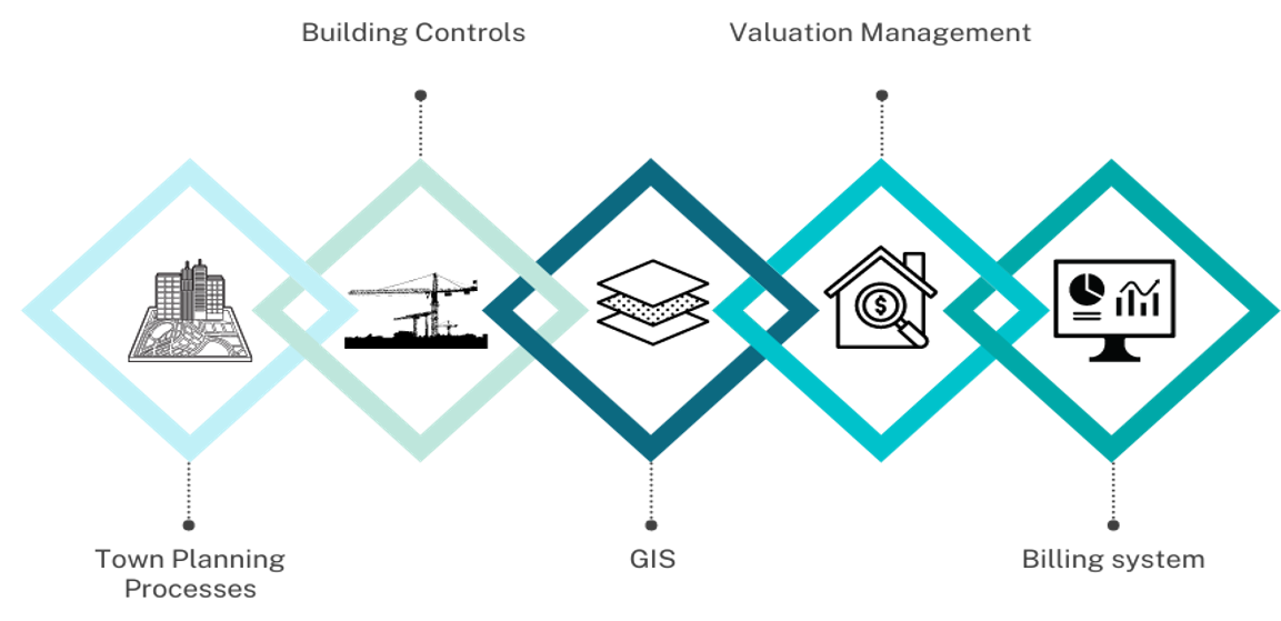
AFLA’S role in the Property Value Chain (PVC)
-
Seamless integration of the Property Value Chain
-
Geo-enabled solution integrating multi departmental activities
-
Centralised storage of all application information
-
Maintains a complete audit trail

The transition from a paper-based system to an online one means…
Geo-enabled
workflow-based solution
Local Authorities have many processes that they need to follow that specifically reference location such as properties and addresses. AFLA has been developed specifically to cater for this by geo-enabling these workflows i.e. by bringing together processes linked to a property or location.
Easily accessible central storage system
All application related information (documents, property location, communications etc) are stored in a central location thereby providing a full audit trial.
Configurable System
Easily configure the workflow, tariffs, timers, templates, reports, and user roles relevant to a specific client.
Online Submissions
Applicants can easily submit applications from anywhere.
Runs on the Esri Platform
Built on the Esri software platform making it fast and reliable.
Fast, reliable and user-friendly
The solution is form-based, eliminating the need for specific GIS qualifications to utilise the modules.
Easily track applications
You can easily track your application status through the online submission portal.
Geo-enabled
workflow-based solution
Local Authorities have many processes that they need to follow that specifically reference location such as properties and addresses. AFLA has been developed specifically to cater for this by geo-enabling these workflows i.e. by bringing together processes linked to a property or location.
Easily accessible central storage system
All application related information (documents, property location, communications etc) are stored in a central location thereby providing a full audit trial.
Configurable System
Easily configure the workflow, tariffs, timers, templates, reports, user roles relevant to a specific client.
Online Submissions
Applicants can easily submit applications from anywhere.
Runs on the Esri Platform
Built on the Esri software platform making it fast and reliable.
Fast, reliable and user-friendly
The solution is form-based, eliminating the need for specific GIS qualifications to utilise the modules.
Easily track applications
You can easily track your application status through the online submission portal.

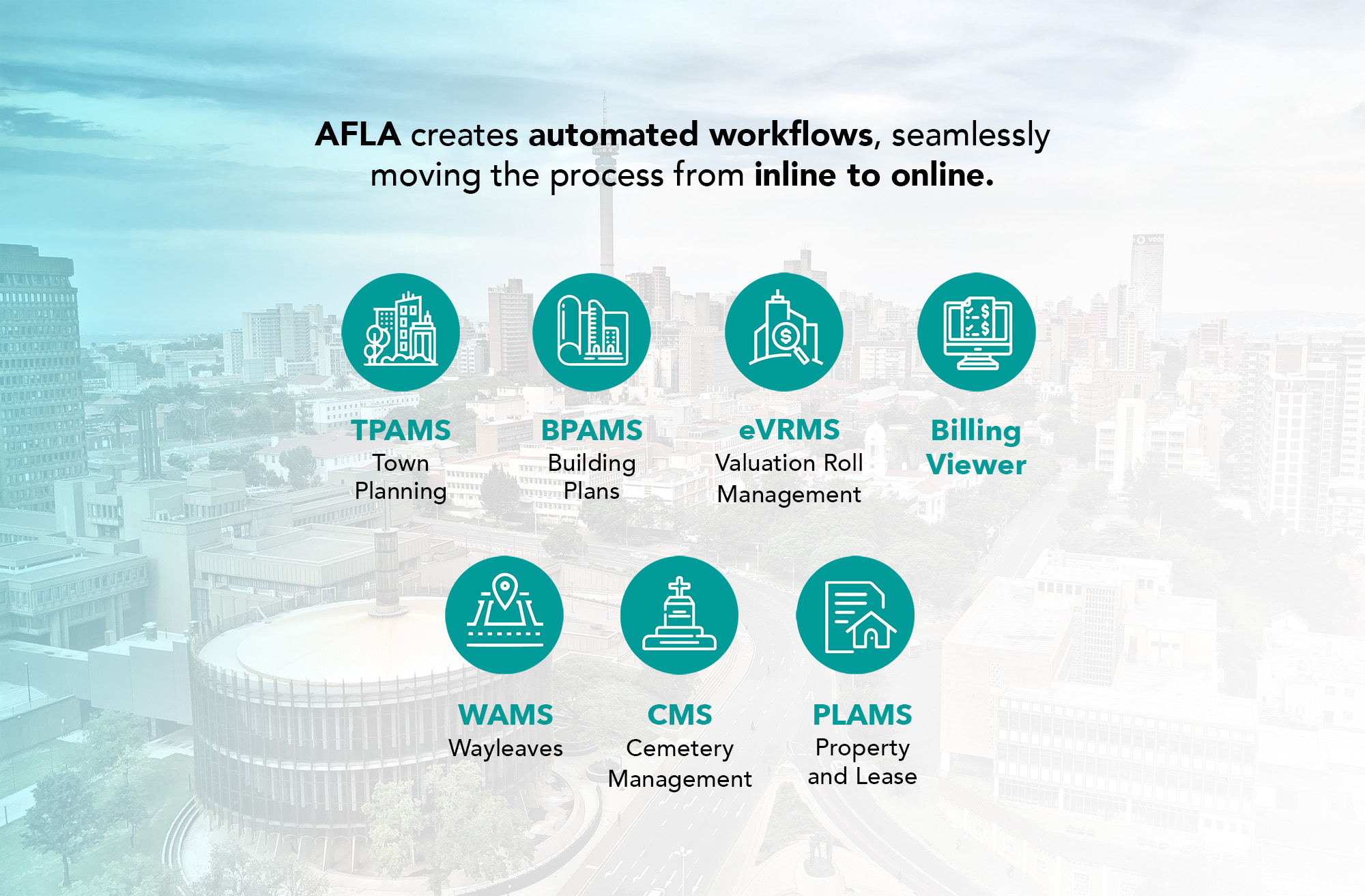
Town Planning Application Management System (TPAMS)
Assisting applicants to electronically lodge land development applications to the municipality, such as, rezoning, subdivision, township establishment, and other town planning related applications.
Building Plans Application Management System (BPAMS)
Assisting applicants to electronically lodge building plans to the municipality for minor building works, alterations, and new builds for residential, commercial, etc. The system generates the required occupational certificates.
Electronic Valuations Roll Management System (eVRMS)
eVRMS is an electronic valuations roll management system that has incorporated the Computer Aided Mass Appraisal (CAMA) methodology. The module ensures MPRA compliance and leverages the latest spatial technology required for the Master File.
Billing Viewer
The Billing Viewer provides a visual representation of the current status of billing at a property level. This is an automated process that updates as the billing information is made available from the financial system i.e. on a daily, weekly or monthly basis. Visualising the billing status at a property level promotes revenue enhancement as you can easily see where there are billing discrepancies.
Wayleaves Application Management System (WAMS)
Assisting applicants to electronically lodge Wayleave Applications to the municipality such as, fibre, telecoms, water, electricity, etc. The system is designed to manage associated road closures.
Cemetery Management System (CMS)
Assisting applicants to electronically lodge applications to the municipalities such as burials and cremations. The system is designed to optimise space in cemeteries and to create a digital burial register.
Property and Lease Application Management System (PLAMS)
Assisting applicants to electronically lodge applications to the municipality such as, acquisition of land/buildings, the disposal of land/buildings and tracking the status of lease agreements on municipal land.
