Solutions for all industries
Apply geographic thinking with user-centric solutions for organisations across a variety of industry sectors. Browse below to see how we can help you and your organisation become location intelligent.

View solutions by industry sector


Local Authorities
Our solutions support:

Explore more with our high value solutions:
ArcGIS for Local Authorities
Digitally transform your local authority business processes and automate key workflows.

National and Provincial Government
Our customers represent the majority of large national and provincial governments in meeting their mandates as policy makers, analysts, data custodians and owners of critical national processes.
Our solutions support:
At the provincial level, we support departments in collecting data needed for performance, monitoring and evaluation, and for the improved delivery of services such as health, education, disaster management and housing as well as the aggregation and democratisation of authoritative spatial data through SDI initiatives.
Utilities and Telco
Our customers range from parastatals to local municipality utility service divisions, to private businesses. What these varying organisations have in common, is that they design, build, operate and maintain critical infrastructure.
Our solutions support:

Explore more with our high value solutions:

Network Information Management
Integrated network management with analysis and integration capabilities for water, electrical and fibre networks.

Asset Management
Manage your organisational assets, life-cycle, maintenance and auditing.
Natural Resources
Users in these inherently geographic industries such as heavy mining, agriculture and forestry support critical business processes using our unique spatially-enabled technology.
Our solutions support:
Explore more with our high value solutions:
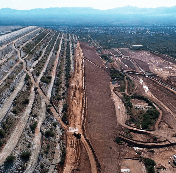
Tailings Management
GISTM compliant solution for monitoring, disclosure and response.
Asset Management
Manage your organisational assets, life-cycle, maintenance and auditing.
Architecture, Engineering, Construction (AEC)
We partner with AEC firms as they deliver specialist services into their respective markets. Our users leverage geospatial technology.
Our solutions support:


Business and Commercial
We focus on location intelligence solutions for retail, banking, insurance, security and real-estate among others. Our users support, develop and innovate with a modern spatial data and mapping system.
Our solutions support:

Explore more with our high value solutions:
Site Selection
Identify optimal sites based on various input factors.

Geocoding
Convert addresses into a map location, one-by-one or in bulk.
Business Data
Discover more about our business data and how it can help you unlock insights into smarter business strategies.
Public Safety and Defence
We work closely with our industry partners to create innovative and novel solutions to challenges around public safety and national security. These solutions focus on the management of data, enablement of mobile workforces, storing of secure and auditable data, scenario planning and advanced predictive analytics as well as providing real-time intelligence and insights to decision makers and the public.
Our solutions support:

Transport, Logistics and Aviation
Our customers in this sector leverage geospatial technology and data to optimise transportation planning.
Our solutions support:
NPO / NGO
Our non-profit programme supports a large number of national and multi-national organisations in conservation, humanitarian support, health services, aid programmes and many others to deliver services to communities in need, when they need it most. We support these users with accessible software fees, technical support and industry engagement and marketing.
We support the following initiatives:

Learn more about how we make a difference to the communities we engage with:

Corporate Social Initiatives
Our corporate responsibility programme is influenced by our company values which aim to positively impact the communities we engage with and to enhance and protect the environment.


Academic Institutions
Our customers in the sector represent institutions that range from school teachers and learners, to lecturers and students, as well as researchers, institutes for R&D and others. Their core focus areas include geospatial, engineering, mining, geology, environment sciences, surveying, town and regional planning, statistics/data science and computer science departments.
We support: